Town defences: The Fosse
Mediaeval Tonbridge was a fortified town. The
castle was its
stronghold, but the whole of the small settlement outside the castle gates was
protected against intruders by a substantial ditch-and-bank structure known
today as the 'Fosse'. This encompassed the town on all sides, except where the
river or its tributaries form a boundary. The route of the Fosse can be seen on the plan below.
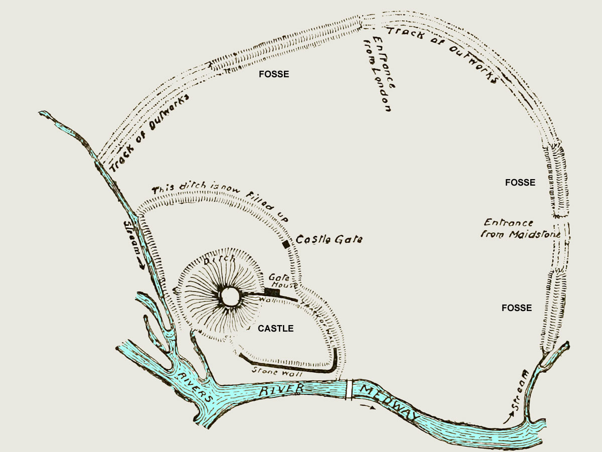
A plan of Tonbridge's mediaeval defences, showing the Castle and Fosse,
originally published in the Victoria County History:
Kent in 1908.
Move the cursor on to the picture to see how it relates to
the present-day street plan.
The Fosse must originally have been an impressive structure. According to the
National Monuments Record there was an earth bank or rampart, up to
10 metres wide and up to 4.5 metres high. Outside this there was a ditch about 6
metres wide and 2.5 metres deep, parts of which may have been filled directly
from the river, while others collected rainwater or were dry. The total length
was about 800 metres, which implies that some 25,000 tonnes of material would
have been moved – all without machinery – during its construction.
Just when the Fosse was constructed is uncertain. It may have been in the
mid-13th century at a time when the Castle was being strengthened and its moat
dug, or it may have been earlier. In 1259 Henry III granted to Richard Earl of
Gloucester a licence to close his town of 'Tonebrugg' with a wall and to
crenellate it (with stone or wooden battlements). This could refer to
constructing something from scratch, or to improving an existing ditch-and-bank
structure. Either way, no evidence has ever been found for the existence of any
stone or wooden fortification atop the rampart, or of any revetment – cladding
of the rampart with a protective layer of stones or other material.
With the rampart in place, the only ways into or out of the town by road were
from the north means of a bridge and gated entrance near where the Ivy House is
today, by a similar eastern entrance near the present
Port Reeve’s House in East
Street, or over the Big Bridge. This arrangement would have facilitated the
collection of tolls.

A view of the remains of the Fosse as it appears from the end of Fosse Road
The route of the Fosse can still be traced today. In the Slade area, a public
footpath between Stafford Road and the end of Fosse Road runs along what was
originally the line of the ditch, while the remains of the rampart, much
overgrown, form a noticeable bank alongside. In the east, an outward-facing
scarp or mud-bank is a conspicuous feature in private gardens between Bordyke
and East Street, and on the south side of East Street. The name
Bor-dyke
itself commemorates the ditch, now filled in, which ran parallel to the street
along what is now the north edge of the Parish Church graveyard.
In 1886 the local architect and antiquarian James Wadmore published the
remarkable drawing shown below. It gives a bird's-eye view of the Town and Castle of
Tonbridge as Wadmore thought they might have appeared in the year 1260. The view is from
the north. The castle appears to dominate the small town, which is
completely enclosed within the Fosse (shown here apparently holding water throughout its
length). The only building outside the ramparts is the
Priory, in the far
distance. As a religious house it perhaps did not need protection.

Bird's-eye view of Tonbridge in 1260, by J F Wadmore (THS 1.012)
▲Top
