|
15.Bank1 |
|
|
|
|
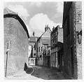
Jeffreys Passage, between the High Street and Bank Street
|

|
|
15.Bard1 |
|
|
|
|
Barden Road: The 'Black Well', pulled down 1882 (Constitutional Club now on the site)
|

|
|
15.Bard3 |
|
|
|
|
Barden Road, pre-1915
|

|
|
15.Bord1 |
|
|
|
|
Bordyke, pre-1914
|

|
|
15.Bord2 |
|
|
|
|
Bordyke Lodge, The Old Barn, pulled down 1914, "GMB, DB, H Beeching walking"
|

|
|
15.Bot1 |
|
|
|
|
Botany, showing demolition of old lodging house
|

|
|
15.Bot2 |
|
|
|
|
Botany, probably late 1920s
|

|
|
15.Brad1 |
|
|
|
|
Bradford Street, looking towards the High Street, during the 1939-45 war
|

|
|
15.Brook1 |
|
|
|
|
Entrance to Brook Street (formerly Hayesden Lane) from Quarry Hill
|

|
|
15.Cast2 |
|
|
|
|
Top of Castle Street, looking into Bank Street
|

|
|
15.Chur2 |
|
|
|
|
Church House, Church Lane, when in use by YMCA
|

|
|
15.Chur3a |
|
|
|
|
Tyger's Head and Church House, Church Lane
|

|
|
15.Chur3b |
|
|
|
|
Church House, Church Lane, when in use by YMCA
|

|
|
15.Chur4 |
|
|
|
|
View up Church Lane
|

|
|
15.Danv1 |
|
|
|
|
Flood in Danvers Road
|

|
|
15.DryH1 |
|
|
|
|
Dry Hill (Shipbourne Road), showing site of fire
|

|
|
15.East1 |
|
|
|
|
East Street, junction with High Street (now Lloyd's Bank), probably early 1890s
|

|
|
15.East2 |
|
|
|
|
East Street, looking west
|

|
|
15.Had2b |
|
|
|
|
Toll gate in Hadlow Road
|

|
|
15.Lond1 |
|
|
|
|
London Road, early 20th century
|

|
|
15.Medw1 |
|
|
|
|
Medway Wharf Road, from Maylam's warehouse, c1920s
|

|
|
15.Pemb1 |
|
|
|
|
Pembury Road, pre-1914
|

|
|
15.Pemb6 |
|
|
|
|
Pembury Road, old cottages on site of future Deakin Leas, c1930s
|

|

|


 1 of 2

 1 of 2